The World Risk Index 2012 ranks the Philippines as 3rd among global disaster hotspots. Of the 15 countries, 8 are island states, including the Philippines, at the highest risk to cyclones, flooding and sea level rise. Despite the 7% growth forecast by the World Bank and Asian Development Bank, our capacities in disaster risk reduction and mitigation have not improved.
Table 1. Top 15 countries with the highest disaster risk

- Source: WorldRiskReport 2012, UNU-EHS
Development, environmental degradation, and the disaster context
Economic growth and wealth production has resulted in rapid urban sprawl in and outside Metro Manila. The seeming lack of open space for development has led to the conversion and redevelopment of properties with existing lower land use such as industrial warehouse spaces, petrol stations and institutional and government uses to higher and more profitable land uses like office and residential with supporting retail facilities.
Additionally, aggressive urbanization has even led to proposals to further reclaim Manila Bay. This transformation requires rigid master planning and infrastructure necessary to support urbanization, economic activities, and sustainable growth. However, in many cases, the necessary supporting infrastructure in and outside of the development area is not proportionate to the projected doubling or tripling and worst, quadrupling in resident population as a result of vertical development and the additional workforce coming from the mixed-use development from the previous single-use of that land. This has placed extreme pressure on the overall environment.
When aggressive development activities are not responsibly regulated by the local government authorities, communities proliferate even in high-risk areas.
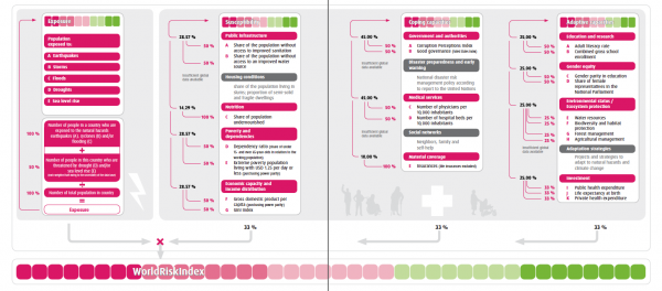
In the WorldRiskReport 2012, high-risk countries have common characteristics:
- High exposure to natural hazards
- High susceptibility to harm, loss, and disruption in an extreme event
- Lack of coping capacities to minimize the negative impacts of natural hazards
- Limited investments in disaster risk reduction
Their characteristics could undermine economic growth, and disrupt business operations. Whether a natural hazard turns into a disaster depends on several vulnerability factors, one of which is the level of development and investment on the one hand or disregard toward improving risk resilience on the other. Urban policies must acknowledge that management structures operate most effectively where there is local accountability and local involvement in the provision of infrastructure, the promotion of socio-economic strategies and the generation of financial resources.
In the case of Metro Manila, the urban sprawl now includes Region IV-A or CALABARZON. To the North, the Bases Conversion and Development Authority (BCDA) is undertaking an ambitious plan to build a 3,500 ha Green City "envisioned to accommodate a 'mix of residential, commercial, agro-industrial, institutional and information technology developments." Growing populations that are now occupying hazard areas such as flood plains are more vulnerable when disasters strike.
Figure 2. Pampanga River Basin Flooding Map

- Growing populations that are now occupying hazard areas such as flood plains are more vulnerable when disasters strike.
Figure 3. Clark Green City Landslide and Flood Susceptibility Map

- Geohazards go beyond administrative boundaries. For businesses, ‘disaster risk does not stop at the factory gates.’
Hazards are part of geographical realities that go beyond administrative boundaries. For businesses, the United Nations Office for Disaster Risk Reduction issues a reminder that 'disaster risk does not stop at the factory gates.'
In Metro Manila alone, several business districts, with significant concentrations of economic assets are exposed to many major hazards.
Businesses in close proximity to the West Valley Fault must shore up risk reduction efforts in partnership with their local governments. After the 7.2 intensity temblor in Bohol and Cebu cities in October 2013, calls for the government and private sector to take immediate and decisive steps toward a more resilient infrastructure has been espoused by the Japan International Coordinating Agency (JICA).
Mr. Tatsuo Narafu, JICA's senior adviser on architectural intervention for disasters, recommends a review of the National Building Code (PD 1096) as well as "enhance the capacity of the engineers and the private sectors to improve the resiliency of public infrastructure."
Renewed calls for stepping up disaster preparedness also came from the Philippine Institute of Volcanology and Seismology (Phivolcs) after the 7.2 magnitude earthquake in Bohol. In the National Capital Region, a 7.2 magnitude earthquake scenario is possible as the West Valley Fault is ripe for movement. Dr. Renato Solidum Jr., Phivolcs Director, said that "the next killer quake may not strike until 2058 but these early government agencies were preparing for the worst. Intense damage can be expected in Marikina, Quezon City, Pasig, Makati, Pateros, Taguig, and Muntinlupa, where the West Valley Fault passes."
On a similar note, Satsohi Kobayashi, director of the Shizuoka Prefecture Disaster Preparedness Center in Japan hoped that there would be a common seismic intensity measurement among countries, even just in Asia, to help promote objective guidelines for measuring the earthquake-resistance of a building and for formulating a common plan of action for emergencies.
With increasing talks about a Big One coming, anecdotal evidence from building engineers and administrators confirm that tenants and future occupiers have already been pro-actively requesting for an updated Structural Integrity Certification report on their office and residential buildings to include the magnitudes of earthquake their buildings can withstand.
Figure 5. Geohazards and Flood Susceptibility of Metro Manila's Central Business District and Business Centers

- Business centers with significant concentrations of investments and economic assets are exposed to many major hazards.
Disaster risk lens in masterplanning
Real estate masterplanning often only entails the identification of demographics; land use; future developments and growth areas; and the mapping of real estate values. However, by leveraging existing information and available knowledge on geohazards (earthquakes and landslides), flooding and other disaster risk, real estate masterplanners can help businesses assess the impacts of major events on locations or client portfolios, their supply chains and operations, and to enable clients to prepare evacuation plans, adaptation and mitigation measures based on various scenarios.
Employing the disaster risk lens includes the following factors in risk analysis and planning:
- Geology / natural features of the land
- Climate
- Large area and/or site geohazards
- Historical data, analysis of major events / time analysis
- Land use
- Resource use
- Development plans in place
- Governance system / political profile
Sources:
- WorldRiskReport 2012, United Nations University Institute for Environment and Human Security (UNU-EHS)
- Cities in the Pacific Rim, Planning Systems and Property Markets